


hikeTicino
คำอธิบายของhikeTicino
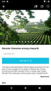
Discover the best itineraries in Ticino, one of the most charming regions anywhere in Switzerland, with the hikeTicino App!
This guide lets you to have all the most important information on more than 150 tourist routes and the related points of interest close to hand at all times.
The app also works offline and without an internet connection.
The App’s main features include:
- weather data for the region, updated with latest MeteoSwiss information (online mode only);
- information on accomodation, points of interest, attractions, events, excursions and restaurants;
- possibility of filtering results by the different regions of Ticino;
- Search for the desired itinerary by surfing the contents, otherwise search by key-word;
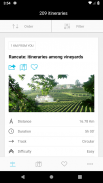
- display the itinerary details and description in order to understand its characteristics;
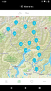
- search the points of interest on the map based on the current position of the device (around me);
- points of interest available offline;
- possibility to save itineraries in the ‘Favourites’ section;
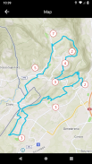
- dowload the itineraries in order to use them offline, maps included;
- display of the road journey to the starting point;
- see pictures of the treks;
- see the video produced by drone in panoramic flight (online mode only);
- retrace the itineraries with Google View Trekker (online mode only);
- with a simple click, telephone, e-mail and internet connection of surrounding facilities;
- all the App’s contents are also available on the reference website hike.ticino.ch.
If you have an internet connection, the contents of the App will be updated automatically.
ค้นพบแผนการเดินทางที่ดีที่สุดในทีชีโนซึ่งเป็นหนึ่งในภูมิภาคที่มีเสน่ห์ที่สุดทุกที่ในสวิตเซอร์แลนด์ด้วยแอป hikeTicino!
คู่มือนี้จะช่วยให้คุณมีข้อมูลที่สำคัญที่สุดในเส้นทางการท่องเที่ยวมากกว่า 150 เส้นทางและจุดที่น่าสนใจที่ใกล้เคียงกันตลอดเวลา
แอพนี้ยังทำงานแบบออฟไลน์และไม่ต้องเชื่อมต่ออินเทอร์เน็ต
คุณสมบัติหลักของแอพประกอบด้วย:
- ข้อมูลสภาพอากาศสำหรับภูมิภาคอัปเดตด้วยข้อมูล MeteoSwiss ล่าสุด (โหมดออนไลน์เท่านั้น)
- ข้อมูลเกี่ยวกับที่พักจุดสนใจสถานที่ท่องเที่ยวกิจกรรมทัศนศึกษาและร้านอาหาร
- ความเป็นไปได้ของการกรองผลลัพธ์ตามภูมิภาคต่างๆของทีชีโน
- ค้นหารายละเอียดการเดินทางที่ต้องการโดยการท่องเนื้อหาหรือค้นหาด้วยคำสำคัญ;
- แสดงรายละเอียดการเดินทางและคำอธิบายเพื่อให้เข้าใจลักษณะของมัน;
- ค้นหาจุดที่น่าสนใจบนแผนที่ตามตำแหน่งปัจจุบันของอุปกรณ์ (รอบตัวฉัน);
- จุดสนใจใช้ได้ออฟไลน์;
- ความเป็นไปได้ที่จะบันทึกรายละเอียดการเดินทางในส่วน "รายการโปรด"
- dowload แผนการเดินทางเพื่อใช้งานออฟไลน์รวมแผนที่;
- แสดงการเดินทางบนถนนสู่จุดเริ่มต้น;
- ดูภาพของเส้นทางเดินป่า;
- ดูวิดีโอที่ผลิตโดยทำเสียงขึ้นจมูกในเที่ยวบินพาโนรามา (โหมดออนไลน์เท่านั้น);
- ย้อนเส้นทางการท่องเที่ยวด้วย Google View Trekker (โหมดออนไลน์เท่านั้น);
- ด้วยการคลิกง่ายโทรศัพท์อีเมลและการเชื่อมต่ออินเทอร์เน็ตของสิ่งอำนวยความสะดวกโดยรอบ
- เนื้อหาทั้งหมดของแอพมีอยู่ในเว็บไซต์อ้างอิง hike.ticino.ch
หากคุณมีการเชื่อมต่ออินเทอร์เน็ตเนื้อหาของแอพจะได้รับการอัพเดตโดยอัตโนมัติ
hikeTicino--เวอร์ชั่น3.0.6
(17-11-2020)hikeTicino - ข้อมูล APK
เวอร์ชั่น APK: 3.0.6แพ็คเกจ: ch.ticinoturismo.hiketicinoเวอร์ชั่นล่าสุดของhikeTicino
เวอร์ชั่นอื่น


แอปในประเภทเดียวกัน


